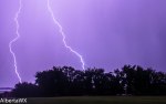
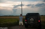
Ryan Keller and Mike Rurak went to intercept a supercell near Bawlf Alberta. What we found when we got there was that the core had already shelved out so we took some structure shots. We proceeded to find a position to take some lightning footage. On the way we met up with TVN weather chaser Braydon Morisseau after messaging him on facebook he pulled over. We checked out his epic setup with his Jeep and Hail guards (see pic below). From what we saw the storm had a mothership structure just before we got there.
Today started out with a severe thunderstorm that moved into the Capital region around 6am, a rare storm only striking in the early morning at best one per year. More storms are firing up and moving east through the afternoon. AlbertaWX chasers Ryan Keller and Mike Rurak will be on these storms in the Red Deer area.
The conditions are prime for suypercells as illistrated by this morning’s epic shelf cloud as it was seen from the Wetaskiwin areas
Heavily sheared shelf moving southeast toward Wetaskiwin at 6:30AM July 22nd
AlbertaWX was out for day 2 of a severe weather outbreak. More supercells with a bigger punch formed up over the northern foothills and made an erratic path southeastward. The first one started near Drayton Valley with more behind it. The easternmost cell turned 90 degrees south from Breton to Rimbey only to turn east again towards areas north of Lacombe, I topped up on gas in Lacombe when the storm took another 90 degrees turn south, pummeling Lacombe and then Red Deer. It was easier to enjoy the 2nd storm as it did not carry the huge hail or the erratic path though the now nocturnal show was just a continuous flashing and no real CGs to speak of. Overall more great structure, and incredible footage of a hail core at night. A tree snapped by the winds, hail splashing down on puddles, and cars getting dented just some of the action in yesterdays chase video.
It would have been nice if the storms fired up earlier instead at dusk as chasing after these cells was not the best idea in the darkness of night. Some good CGs would have been nice as well.
More severe setups are in the offing, Monday(July 22nd), and Wednesday(July 24th) just the first two. The weekend looks ripe once again with supercells, Dewpoints could rise into the 20Cs as well.