
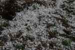
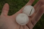
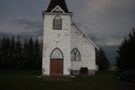
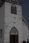
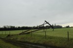
AlbertWX was on the scene of not one but two monster supercells. We intercepted the cells near Millet and nearly got cored ourselves! Residents reported tennisball sized hail in places. Cars were trashed streets were flooded and siding looked like it was shot up with a shotgun.


Possible tornadic setup for Monday
Shear values of 50-60kt in the high levels and 30-40kt in the mid levels coupled with mixed layer cape values of 2250 are going to be a recipe for an excellent setup for Monday in central and southern Alberta. Me and Mike will be out on Monday if the models hold we will be staging somewhere south of Edmonton most likely Red Deer. This setup has the potential to unleash large tornadoes and large hail. I fully expect that Environment Canada will be issuing severe thunderstorm watches by noon. Sunday also looks like some possibility of supercells in the region as well. Stay tuned to AlbertaWX for updates!
Posted in Uncategorized
Tornado warning for Red Deer!
City of Red Deer
8:40 PM MDT Thursday 07 July 2011
Tornado warning for
City of Red Deer issued
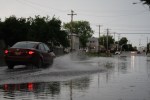
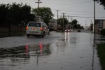
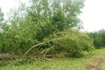
At 8.30 PM MDT RCMP reports indicate a tornado on the ground 5 km west of Innisfail. The storm is moving northeast at 30 km/h. Earlier public reports indicate that this tornado initially touched down near 8.12 PM MDT. This storm also has the potential to produce very heavy downpours and very large hail.
This is a warning that severe thunderstorms with tornadoes are imminent or occurring in these regions. Monitor weather conditions. Take immediate safety precautions.
Please refer to the latest public forecasts for further details.
A warm, moist airmass is in place through Central Alberta with cooling coming in aloft from a developing weather system. Thunderstorms have started to trigger along the foothills and will track into Central Alberta this evening. Some of these thunderstorms are expected to become severe giving large hail, strong winds and heavy rain.
Posted in Uncategorized
