Author Archives: Mike R

Significant snow falling in southern Alberta. Warnings for parts of southern Alberta

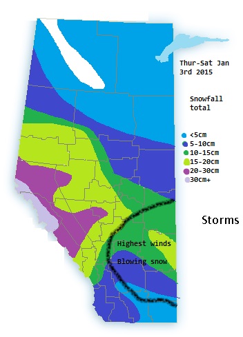
Right up until today the models were in disarray with the current snowfall, thus I was not able to safely make an accurate forecast.

The GEM and GFS were showing low accumulations of 5cm or less over the south end of the province, however the NAM was predicting up to 20cm of a wide swath of southern Alberta

So the NAM was the accurate model for this round of snow.

http://weather.gc.ca/warnings/index_e.html?prov=ab

Updated Snow amounts and warnings issued for snowfall

New year 2015 snowstorm
Custom drawn map of expected 3 day snowfall amounts

With about 12 hours now of lead time the models are more in alignment for the incoming snowstorm.

Highest snowfall total are expected in the northern foothills eastward in to the capital region and south. I would expect warnings to be expanded a bit more south and east as some models show the heaviest bands between Edmonton and Red deer.

Models hint at the highest winds being in east central Alberta, around 30-50km/h in spots giving the risk of blowing snow and white-out conditions in those areas. Winds in most other areas in the 20-40km/h range or less will still give poor conditions along the QE2, Yellowhead and other roadways farther west

Long track thunderstorms bring Edmonton’s first major storm and trigger tornadoes in Saskatchewan

What started as a small LP supercell in western Alberta is still going more than 24 hours later. The storm rapidly intensified into a powerful MCS as it went through the Edmonton area in the middle of the night. Frequent lightning, strong winds, dime sized hail and very heavy rains pounded the area through the night and well into the morning passing into Saskatchewan by 9:30am. by the afternoon it took advantage of daytime heating and intensified even more. producing several tornadoes.

More storms are expected today and tonight