Author Archives: Mike R

Severe thunderstorms break out in Alberta, barely out of the swamps!

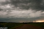
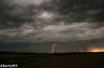
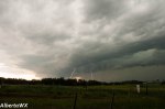
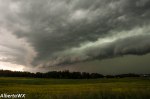
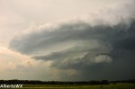
After a hot and humid day severe thunderstorms broke out over northwestern Alberta and the northern foothills. A few of these stormed out of the bush and muskeg and into the Barrhead and Mayorthorpe areas, Chaser Ryan Keller was able to intercept the storms just before they became a squall line. The storms produced some of the best structure of the year for AlbertaWX.

I(Mike Rurak) Busted out twice today, Had the first storm die on me near Alder flats and a 2nd squall out and die before making it out.

The previous forecast was accurate for the yellow head WEST of Evansburg. HOWEVER the Drayton valley and Pigeon lake regions got nothing from the set-up. The Barrhead and RMH regions was not expected to get the worst of the storms but it however did with reports of golfball sized hail.
Overall the storms were 50-100km to the Northwest of the initial forecast.

MLCAPE of up to 3500 and EHI values of 4 sat completely unrealized under the cap as we suspected. So strong that a cold front is sweeping the high dewpoints away without any convection from the strong lift with the cold front.
Would have to be a very strong cap to keep down a lifted index of -9 and a trigger(the cold front)

Forecast for June is now in, Lots of thunderstorms and some snow. WAIT? Snow?

While June is not expected to run colder than normal a strong cold front mid week is expected too cool the air enough for snow to fall. Accumulations are all over the place in the models but it is expected late week, afterwards the temperatures are expected to quickly shoot back into the 20s.

http://www.wunderground.com/blog/Mikeman444/comment.html?entrynum=84

So far we have documented 6 thunderstorms, most were quite weak as it is still early in the year for supercells.

Video of a close strike on May 31st

A new month, new extremes

After yet another cold April we may not see the 30C+ weather that usered in May of 2013. In fact we are about to break a 4 year break form May snowfall here at ALbertaWX. Acumulating snow is expected early next week, though not the kind of snow dumps we saw in 2010(last time it snowed in May) But this time coming with not just a few days but a whole week of temperatures up to 10C colder than normal, such has not been seen this time of year since 2003. Due to extreme patterns in the jet stream so late in the year it is likely May 2014 will continue to see weather extremes much like 2010 where near 30C temperatures were followed by heavy snow just a few days later.

Here is my May 2014 forecast, Only a few more weeks an we might be seeing our first severe WX of 2014.

http://www.wunderground.com/blog/Mikeman444/comment.html?entrynum=83