Author Archives: Mike R

Record breaking rainfall possible in large areas of Alberta!

Starting tonight and lasting partly into Wednesday amounts of 30-70mm are expected to fall over a large part of Alberta. The significance of this system is the time of year. All time records for a singly day rainfall in April are lower, around 25-50mm. This means that the forecast amounts are record breaking.

I’ve made this map to show where I believe the heaviest rain could fall. The Drayton Valley, Pigeon Lake area could see the most

Image


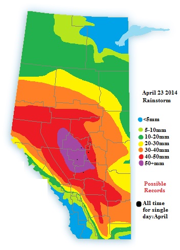
While climate Data seems to be hard to find I have found a few sites in the heaviest rains that may set a new monthly 24 hour rainfall record. In which the forecast is within 5mm or is experted to exceed the record

Edmonton intl: 43.4mm set on the 23rd of April 1990(daily plus monthly record)

Edmonton City centre: 27.2mm set on the 20th of April 1940

Camrose: 22.1mm set on the 30th of April 1951

Stony plain: 40.2mm set on the 23rd of April 1990(daily plus monthly record)

Wetaskiwin: 21.6mm set on the 23rd of Arpil 1990(daily plus monthly record)

Nordegg: 21.2mm set on the 24th of April 1983

Red Deer: 48mm set on the 30th of April 1951

Whitecourt: 24.2mm set of the 24th of April 1991

Stay tune for more updates. EC will likely issue a summary of the if records are broken.

Spring Forecast for 2014 released: Best of lightning 2013 finished!

After such a brutal winter were hoping for an early spring, we know this is not the case. cold and snowy winters tend to delay the arrival of spring weather due to the mountains of snow and ice reflecting the spring sunlight. Here is my Spring 2014 forecast.

http://www.wunderground.com/blog/Mikeman444/comment.html?entrynum=81

Also of note, After quite a bit of delay I finished Best Of Lighting 2013 early this month.

Extreme cold expected to dominate this Weekend.

Starting the month of March usually brings more spring like weather, this year however will ring in March with the coldest temperatures in half a decade. Official forecasts for many areas expect temperatures to plunged well toward the -40C mark. Some model runs even hit at pockets of east-central Alberta dipping to an incredible -50C. There is a strong chance of at least 3 dozen stations shattering records by as much as 10 degrees and some even eclipsing all time records. There were some hints of a weak pacific push that could keep the sub -40s away form the Edmonton/Calgary corridor but the most recent model runs are pointing that being too late to prevent significant record lows.

Current all time Records that may be set Saturday morning
Legend:
Close: within 5C of record
Break: Break record
Shatter: Break record by up to 10C
Annihilate: break record by more than 10C

Coronation: May shatter it’s all time low of -44.4C. And annihilate the March of of -35.6C record by 10 degrees.
Edmonton city centre: May come close to it’s all time March record of -36.1C set in 1939
Edmonton INTL: May come close a new March record of -42.7C set in 2009
Camrose: May break its all time March record of -42.8C set in 1951
Red Deer: May come close to it’s all time March record of -42.8C set in 1951
Loydminster: May shatter it’s all time March record of -36.7C set in 2003
Vegreville: May break it’s all time record of -42C set in 2003
Fort Mcmurray: May come close to it’s all time March record of -44.4C set in 1962
Calgary: May break it’s all time March record of -37.2C set in 1951

Stay tune for official report this Sunday, records could fall that day as well.