
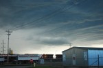
Highs in the mid to upper 20s combined with dews in the mid teens should spark some isolated severe storms today. With MLCPAPE near 1250 with minimal shear, pulse storms are most likely today into tonight, a slight chance of a longer lived storm or squall line. Stay tuned to AlbertaWX for updates

Author Archives: Mike R
Slight WX risk today
Posted in Uncategorized
Aug 5th/6th recap: nothing at AlbertaWX
While wild weather did wreak havoc in many areas it did not do so at a time and area for us to come up with anything.
Friday started in the south around Calgary, the city was hit hard by a slow moving storm that triggered deadly flash floods and piles of hail that dented cars and shredded trees.
The 2nd round of weather came roaring down the Yellowhead with frequent ground strikes over Edmonton and towards the SK border. The storm hit while Ryan was at his at work, Around 10 lightning strikes hit within a block while the severe lightning storm passed over Edmonton. No footage was shot due to security regulations. Nothing from the 2 lines hit the Wetaskiwin area so I(Mike) failed to get anything either. the cloud from the storm was also just enough to shut out any chance of seeing the geomagnetic storm while it was still strong.
Round 3 hit Saturday with warnings for areas north of Calgary to Red deer and the SK border, a couple weak cells of the north edge of the system hit the Wetaskiwin area with some rain and the odd lightning flash.
Posted in Uncategorized
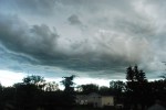
Risk of severe WX today into tomorrow
Severe thunderstorms are possible today into the overnight and tomorrow. MLCAPEs of 1000-1750 today along the foothills where the storms will form and move east through the night. Shear is low for today but will grow through the night and into tomorrow. The highest risk tomorrow is along the SK border from Loydminster to Medicine Hat, MLCAPE nearing 2000 with 30-45kt shear on all levels in the Alberta side of the CAPE. Severe pulse storms today becoming weak meso overnight, stronger supercells are possible tomorrow
Posted in Uncategorized
