Author Archives: Mike R

May 2016 Forecast: Still under the blowtorch, but change could be coming

Hot and dry conditions remain in place as we go into May, April finished off 2-5C above normal and very dry with some parts of the province not receiving more than a millimetre or two of rainfall which is less than 10% of the normal April precip. Temperatures over much of the province managed to surpass the 25C mark and 30C in the NW part of the province. Grande Prairie set a new all time record for the month on the 18th at 29.4C(old 29.2C on Apr 25th 1977). April 2016 finished off one of the warmest in the last half century. Continuing a 4 month long string of well above normal months.

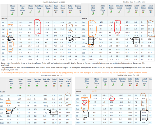
The effect of the continued warmth is a violent start to the fire season and trees are now in leaf 3 to 4 weeks early. Current long range forecasts show more near 30C heat, this time more widespread in store in May However there is an interesting similarity with other Major El Nino years, particularly ones that transition into a Moderate-Strong La Nina. The month of June during the 4 analogue years(1998,1988,1983,1973) had well above normal rainfall, in some cases nearly double the normal amount. And some of those years saw the change to that rainy period at the end of May. It is not known if this is a hallmark of an El Nino-La Nina transition or a coincidence.

May overall could be the 5th hot month in a row; with temperatures expected to be up to 5C warmer than normal in the northern Part of the province. Rainfall is likely to be below to well below normal with the exeption of parts of the south foothills and Rockies. However we are entering the convective season, so rainfall may vary dramatically from the forecast with a good thunderstorm.

May 1-10: Hot and dry. temperatures nearing 32C in eastern Alberta at times. Some potential for thunderstorms.

May 10-20:Warm with a few thunderstorms, Hot in south-eastern Alberta. Possibility of a few wetter days. Notable Chance of a thunderstorm outbreak in Central Alberta

May 20-31: Possible transition to a rainy pattern, otherwise another potential burst of heat. Severe thunderstorms begin

Below is a something I threw together showing the similarities regarding June following Major El Nino(station used, Edmonton INTL A)

Post Nino June rain.png


April 2016 outlook: Another warm month

While El Nino is now weakening fast and about to give way to La Nina in the coming months. the effects El Nino will linger for another month or two.

Overall April 2016 will be above to well above average for temperatures and dry.

April 1-10: warm, windy, and dry

April 10-20: Warm and dry, some windy days. little rain or snow

April 20-30: Warm to hot, remaining dry. Small chance of a rain or snow event as the month ends. Windy

Spring 2016 Forecast.

After a winter that at times(mid-late Dec) seemed lacking in terms of warmth for a super El Nino. The month of February took off with temperature anomalies as high as 8C above normal. While not the warmest February on record it still ranks in the top 5. Dec-Feb 2015/16 finished off warmer than that seen during the 1997/98 Elnino. The main difference is the Lack of a big January cold snap and February(and not Dec) having the very warm temperatures. By the end of the month temperatures soared to 15C as far north as Edmonton. Cold weather was isolated to 1 or 2 days at a time. “winter” as described by Canadians lasted from Mid December through to Mid January.

Spring shows the same pattern if not stronger, peaking in March and Early April.

March: Overall very warm and dry. There is the potential for top 5 warmest much like February.

March 1-10: very mild, dry, one or two cold days

March 11-20: Mild to very mild, dry with day or two of cooler weather with rain/snow.

March 21-31: Very mild. Almost summer-like in southern Alberta and dry. The early heat might trigger the first major fires of the season and a good chance of dust storms and thunderstorms throughout most of the agricultural regions of Alberta. Early arrival of allergy season

April: Warm. Remaining very dry. Fire season becomes quite active.

April 1-15: Mild to Warm, small chance of a snowfall. A few very windy days with dust storms possible. Extremely dry in some areas. Humidity could dip below 10%

April 16-30: Warm to hot: a few cooler days with rain. Early leaf out leads to rising humidity. A chance of the first Severe thunderstorm of 2016 in the province.

May: Warm to hot: closest to normal of the 3 spring months. Normal to below normal precipitation.

May 1-15: more seasonal with a chance of a heatwave or two. Dry weather broken by thunderstorms

May 15-31: Possible change to cooler and significantly wetter pattern. Severe thunderstorm outbreak potental