Winter 2018 forecast: Uncertain but could be a cold one.

After a fall that averaged near to above normal quenched by November cold and snow. Winter 2017/18 is likely to have even more temperature swings, more than we saw last year with swings from the minus 30s to near the all time highs in mere weeks.

Winter should finish off with near to below normal temperatures and generally lower snowfall outside of the rocky mountains and foothills.

The Main factor in play this season is a moderate La Nina, and favors below normal temperatures but may be moderated by other factors such as the AO, PDO, and NAO

While December is very mild; January will likely see the coldest temperatures of the season, possibly into February and the stubborn cold May linger well into March making for a late spring.

December: Well above normal temperatures and very dry. A small amount of snow might save Edmonton and Calgary from a brown Christmas. It may only be 5cm or so but it’s enough to make Christmas white

January: Very cold at times, remaining dry.

February: chance of a thaw but overall near to colder than normal. Snowfall close to normal.

Real significant snowfall might not come until February or March as the dominant air masses in play are very low in moisture content.

The risk of blizzards is higher than a normal winter as the chance of high winds is higher.

Fall 2017 Forecast

After a hot, smokey and dry summer fall will continue the warm pattern but with a few breaks of colder and wetter weather. The warmest Month compared to normal will be October

The warmest anomalies should be in the Southeast part of the province. near normal in northwestern Alberta. A trough to the west and ridge to the east setup for much of the fall should beef up precip amounts and may cause similar issues to last year during harvest.

September: Near normal temperatures overall and wetter. Periods of hot and dry mixed with snowy and cold spells should equalize anomalies and Sept should finish near normal.

October: Much warmer than normal and wet. Warm weather over long periods with ample rainfall; This combo may also result in some very late season thunderstorm outbreaks. Primary areas are along the rim of the ridge including the QE2 corridor and the Yellow head corridor.

November: Warmer than normal, near normal precip. There is some uncertainty with November due to a developing La Nina event. At this point very warm temperatures at least for the first half, however the transition to winter might be slow or delayed into December.

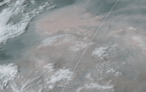
“Hottest day of the year” smothered! BC smoke blots out the SUN!

Thick smoke blots out the sun over a large portion of Alberta and Saskatchewan.nuclearwinter.png

What was forecast to be the hottest day of 2017 was anything but that. Very thick smoke blew in from the many thousands of massive forest fires blotting out the sun for most of the day. In the worst hit area around Edmonton the sun was barely visible as a faint red dot. The temperature originally forecast to reach 33C barely got to 24C. nearly ten degrees colder!. The International airport only reached around 23C. Further south the smoke did clear off enough by early afternoon to reach the 30s. Red deer at 31C and Calgary at 32C.

Today(August 30 2017) Now stands as a prime example as summers grow hotter and drier there will be fewer hot days, that is a bit strange but it’s quite simple. The hot and dry weather leads to so many fires that the smoke blots out the sun like we saw today, cutting up to 10 degrees Celsius from the high temperature. The hot muggy days remain however because there are no evergreen forests between us and the Gulf of Mexico to ignite. No forest=No forest fire

Another unfortunate factor is that as the sun heats the smoke cloud instead of the ground, it creates a strong inversion. This kills convection and severely reduces rainfall as a result, even though the smoke provides more condensation nuclei for the raindrops. Drought conditions appear to be worsening across the province. Long range forecasts show very dry conditions lasting into the winter meaning spring 2018 will also be in severe drought, regardless of how much snow falls

21291248_10212059911084339_1223903570_n.jpg

Withered grass and trees along Gaetz Ave in Red Deer.

21267809_10212059732799882_1881367696_o.jpg

Parched boulevard in Red Deer

An extreme example of this effect can be seen in the small town of Camrose, Alberta, where “because of the smoke” they will set an all time record for the “hottest summer of record without hitting 30C”. Temperatures as high as they have ever got to without going over 30.0C. The smoke smothered the hottest days. Other locations have had a much warmer than normal summer but had fewer than average hot days.

The pattern is likely to continue well into the fall. While there is a good chance of 30C+ weather on multiple occasions in September; it is likely smoke will smother those days as well.

We could be dealing with this acrid smoke well into October.