
June ended around 2C warmer than normal, the warmest June in 13 years and very dry. hundreds of forest fires are currently burning in the north. This is already leading to significantly reduced visibility and air quality issues. Sound familiar, just as we saw in 2014. It’s even hotter this year so thunderstorm activity started at much high levels. June had a decent level of thunderstorm activity.
For July I looked at various factors. El Nino, persistent ridging already present and how these ridges break down.
The ridging seems to undulate in a way that prevents much for convection and moisture. Models(NAM) already show the same with the first “brief” ridging of July, heat goes away for a day or two without much moisture for thunderstorms. I’ve plotted thunderstorm activity based on this pattern, and where instability and moisture are most prevalent.
Overall July 2015 should be much warmer than normal for the entire province, Some models now cover the whole month. CFSv2 show the month of July being between 4 and 7 degrees warmer than normal everywhere in the province, that model is usually warm biased so a 2-5 degree anomaly is most likely
Rainfall for the month of July should be very low with the exception of the southern foothills as stalled patterns should yield daily showers and thunderstorms. There is a chance some regions in the north may not receive a drop during the entire month.

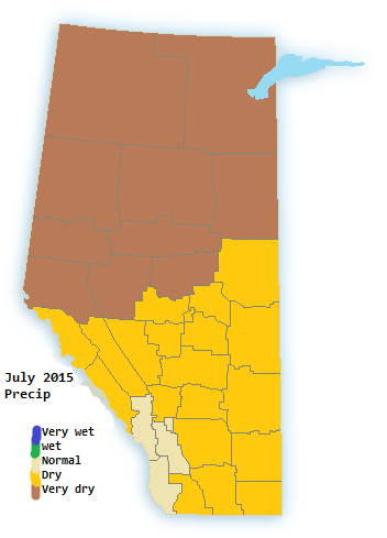
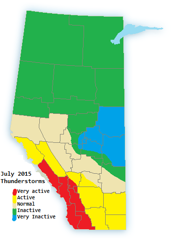
July 1-10: Warm to hot, Thunderstorms in the south, very dry in central and Northern Alberta
July 10-20:Very hot, very dry. Thunderstorms are scarce
July 20-31:Warm to Very hot, Extremely dry. Small chance of a major severe outbreak in central and north but overall very little thunderstorm activity outside of the mountains and foothills.
As drought continues to develop the chance is quickly increasing of extreme drought in parts of the province, in that case major dust storms may become a problem as we head toward late summer.
