
It was without a doubt an eventful evening. Virtually all our members of the AlbertaWX team (not to mention several other chasers in the vicinity) were stationed near a fast moving squall line as it raced through central parts of the province on Monday. What originally appeared to be a marginally severe setup for us ultimately brought us an impressive show; needless to say, one that certainly made up for the lack of activity we’ve seen this year by far.

Photo taken by Chrisy Larualee Hearn. July 20, 2015. Matt Johnson from Prairie Storm Chasers can be seen on the right.

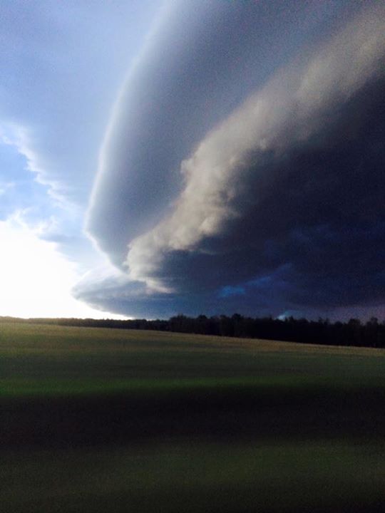
Bow Echo riding parallel to Hwy 16. 8:20 PM MDT, July 20, 2015
What started out as a cluster of strong cells near the Alberta elbow, quickly morphed into a bow echo as it passed east of Edson by 8:00. As it neared the Capital Region, the line extended from the Athabasca to Ponoka areas. Reports of up to 130 km/h winds were reported as the storm approached Parkland county and hail larger than golfballs were reported near Edson.
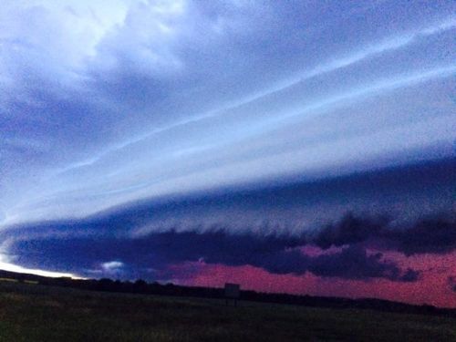
The radar shot shows the bow echo at its most intense as it neared Drayton Valley. Stationed near Drayton Valley were Cheemo and Chrissy, who watched as the menacing shelf cloud organized. These pictures taken by them basically speak for themselves!

Leading edge of the monster storm as seen from Drayton Valley. Credit: Cheemo McIntyre, Chrisy Larualee Hearn
 Between Warburg and Drayton Valley. Credit: Cheemo McIntyre, Chrisy Larualee Hearn

Monster shelf cloud approaching Drayton Valley. Credit: Cheemo McIntyre, Chrisy Larualee Hearn

Our own take on the severe weather threat.
With the threat of the strong winds themselves we went ahead and put out a moderate risk on our Facebook page. We took chances and included Edmonton in the area as well since we agreed that these storms would likely hold for quite a while. Sure enough, a Severe thunderstorm watch was issued for Edmonton by Environment Canada shortly after.
Some lowering also became apparent despite the low threat for tornadic activity. Our own Cheemo and Chrisy, were among the few chasers to report lowering. Storm chaser Braydon Morisseau, who was also out nearby caught this.
Lowering West of Buck Lake, Alberta #abstorm 9:00PM @PrairieChasers pic.twitter.com/192nIFF9wG
— Braydon Morisseau (@BraydonMoreSo) July 21, 2015
These two shots were taken by Mike Rurak, who was positioned nearby..

Near Warburg. July 20, 2015. Credit: Mike Rurak

Near Warburg. July 20, 2015. Credit: Mike Rurak
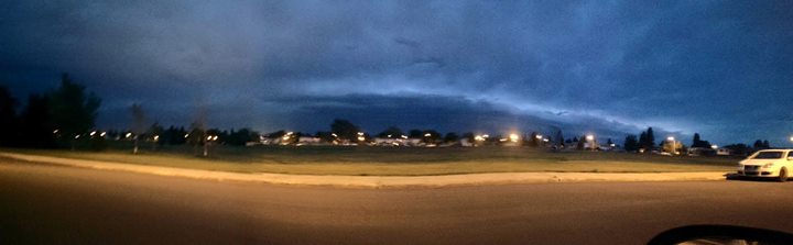
Those storms managed to hold as the line of storms approached Edmonton. Caught from home base, the shelf cloud remained visible; indicating that the storm hadn’t lost steam just yet. Severe thunderstorm warnings were issued for the city just after 10:00 PM. It’s worth noting that some areas such as Wabamun had warnings issued well in advance of the storm while it was only just passing over Drayton Valley. It was pretty clear that even EC wasn’t taking chances.
ALERT Severe Thunderstorm Warning now includes City of Edmonton, Leduc, Beaumont, Wetaskiwin and Millet #abstorm pic.twitter.com/xoLwXsWchX
— Brandon Houck (@HouckisPokise) July 21, 2015
546
WUCN16 CWWG 210408
SEVERE THUNDERSTORM WARNING
FOR NORTHERN ALBERTA
UPDATED BY ENVIRONMENT CANADA
AT 10:08 P.M. MDT MONDAY 20 JULY 2015.
---------------------------------------------------------------------
SEVERE THUNDERSTORM WARNING FOR:
=NEW= CITY OF EDMONTON - ST. ALBERT - SHERWOOD PARK
=NEW= LEDUC CO. NEAR LEDUC BEAUMONT AND KAVANAGH
=NEW= CO. OF WETASKIWIN NEAR WETASKIWIN MILLET AND HWY 2
      PARKLAND CO. NEAR WABAMUN CARVEL AND KEEPHILLS
      PARKLAND CO. NEAR SPRUCE GROVE AND STONY PLAIN
      LEDUC CO. NEAR WARBURG THORSBY AND PIGEON LAKE
      LEDUC CO. NEAR CALMAR AND DEVON
      CO. OF WETASKIWIN NEAR PIGEON LAKE.

SEVERE THUNDERSTORM WARNING ENDED FOR:
      BRAZEAU CO. NEAR DRAYTON VALLEY AND BRETON
      CO. OF WETASKIWIN NEAR ALDER FLATS AND WINFIELD
      PONOKA CO. NEAR RIMBEY BLUFFTON AND HOADLEY
      PONOKA CO. NEAR CRESTOMERE.

---------------------------------------------------------------------
==DISCUSSION==

UPDATED OR ENDED BY 12:08 A.M. MDT.

STRONG LINE OF THUNDERSTORMS EXTENDING FROM 25 KM NORTH OF ROCKY
MOUNTAIN HOUSE TO JUST WEST OF SPRUCE GROVE. THE LINE IS MOVING EAST
AT 50 KM/H.

TO REPORT SEVERE WEATHER, PLEASE CALL 1-800-239-0484.

TAKE COVER IMMEDIATELY, IF THREATENING WEATHER APPROACHES. FAST
MOVING WATER ACROSS A ROAD CAN SWEEP A VEHICLE AWAY. VERY LARGE HAIL
CAN DAMAGE PROPERTY, BREAK WINDOWS, DENT VEHICLES AND CAUSE SERIOUS
INJURY. VERY STRONG WIND GUSTS CAN DAMAGE BUILDINGS, DOWN TREES AND
BLOW LARGE VEHICLES OFF THE ROAD. GO INDOORS AND MOVE AWAY FROM
WINDOWS AND SKYLIGHTS. AVOID AREAS OF THE BUILDING THAT COULD BE
AFFECTED BY FALLING DEBRIS SUCH AS TREE LIMBS. STAY ON THE LOWER
FLOOR OF YOUR HOME OR BUILDING AND IF THE STORM IS PARTICULARLY
SEVERE GO TO THE BASEMENT. TENTS, VEHICLES, MOBILE HOMES AND
TRAILERS OFFER LITTLE PROTECTION.

ENVIRONMENT CANADA METEOROLOGISTS WILL UPDATE ALERTS AS REQUIRED.
PLEASE MONITOR LOCAL MEDIA OR WEATHERADIO. TO REPORT SEVERE WEATHER,
SEND AN EMAIL TO STORM(AT)EC.GC.CA OR TWEET REPORTS TO (HASH)ABSTORM.

HTTP://WEATHER.GC.CA/WARNINGS/INDEX(UNDERSCORE)E.HTML?PROV=AB

END/MSC
At 10:30pm – storms moving thru #yegwx area. Looks like heaviest precip will be over south side of the city. pic.twitter.com/zoDTwMB5k8
— Josh Classen (@joshclassenCTV) July 21, 2015
Below are some shots taken by Nick Abra as he watched from the north end . At this point it became increasingly difficult to see as we started to lose daylight. Still nonetheless, plenty of lightning, which could still be seen even as the line was still between Drayton Valley and Entwhistle; over 100 km away! Looked like a pretty good handful of positive strikes as well.

Shelf Cloud approaching at 10:30PM. Photo taken by Nick Abra
Shelf Cloud approaching at 10:30PM. Photo taken by Nick Abra
From the south side, Mike Walters got some interesting video showing dramatic shift in winds as the storm pushed through (at 2:00).
