
The hot and dry pattern since March will only end “briefly”.
A wetter and cooler September should offer a short break before warm and dry conditions return late in the month or early – mid Oct and likely to last toward the new year.
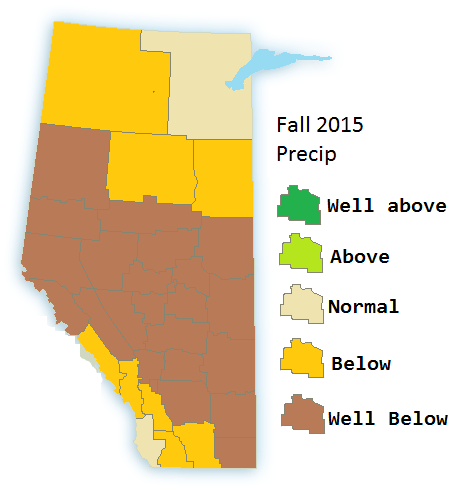
Overall Fall 2015 will be warmer and drier than normal over much of Alberta.
September


September will likely break a chain of hot months as only the south-east part of the province should be much warmer than normal and the Western part being cooler than normal. Likely it will seem like winter comes early but after that it is likely to go in reverse. While the additional rainfall/snowfall is welcome during the drought it is badly timed.
A special note is with the combination of cooler than normal temperatures and above normal precip at this time of year means the risk of tree damage due to heavy snow. This risk would be in the western and north western part of the province.
October: The colder and wetter pattern should once again be replaced with a warm and dry pattern by the start of the month. dominating much of the province.
November: The warm and dry weather will continue and strengthen, due to persistent drought conditions and a higher chance of strong Chinook events like the ones seen in 2012 dust storms should be noted as a risk over much of the open regions of the province. The fire risk will also run quite high for much of Alberta.
