Author Archives: Mike R

August 2015 Forecast

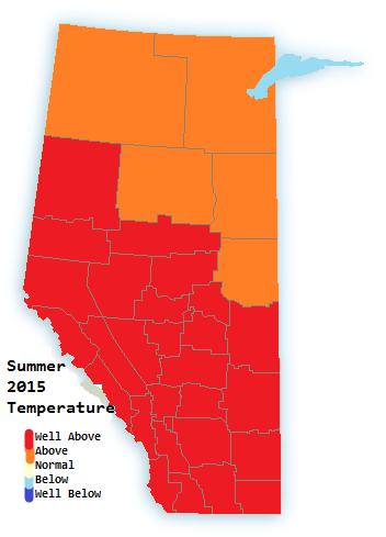
The first 2 months of summer we a solid ~2°C warmer than normal for the bulk of the province. August is likely to continue the trend.

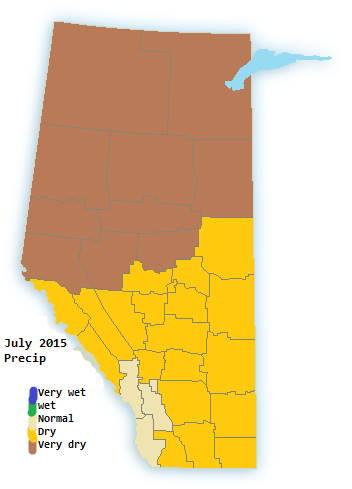
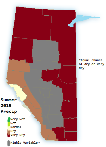
Overall We expect August to be warmer to much warmer than normal for all but the North-east part of the province. Precipitation should be below normal over central and southern Alberta with sightly wetter than normal in the extreme north-east.

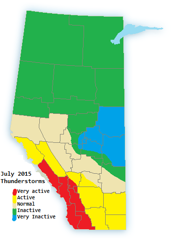
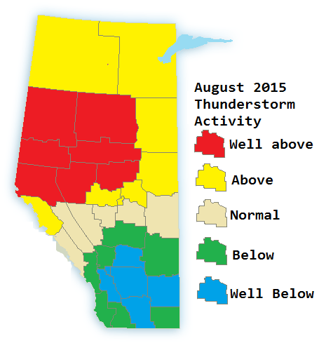
Thunderstorm Activity is ramping up along the yellowhead and into north-western Alberta and calming down considerably in southern Alberta. This is in part due to a stronger Jet courtesy El Nino.

Aug 2015 tempAug 2015 precipAug 2015 Storm

Details:

August 1-10: Alternating periods of hot and dry with cool and wet. Frequent thunderstorm activity north. Particularly at night

August 10-20: Alternating hot and cool north, Hot south. Frequent severe thunderstorms possible over the capital region.

August 20-30: becoming Hot and dry as broad ridging extends into the mountains from the west. Alternating cold and warm-hot elsewhere. Thunderstorm activity prominent along the yellowhead

July 2015 Forecast. Hot but not record hot

June ended around 2C warmer than normal, the warmest June in 13 years and very dry. hundreds of forest fires are currently burning in the north. This is already leading to significantly reduced visibility and air quality issues. Sound familiar, just as we saw in 2014. It’s even hotter this year so thunderstorm activity started at much high levels. June had a decent level of thunderstorm activity.

For July I looked at various factors. El Nino, persistent ridging already present and how these ridges break down.

The ridging seems to undulate in a way that prevents much for convection and moisture. Models(NAM) already show the same with the first “brief” ridging of July, heat goes away for a day or two without much moisture for thunderstorms. I’ve plotted thunderstorm activity based on this pattern, and where instability and moisture are most prevalent.

Overall July 2015 should be  much warmer than normal for the entire province, Some models now cover the whole month. CFSv2 show the month of July being between 4 and 7 degrees warmer than normal everywhere in the province, that model is usually warm biased so a 2-5 degree anomaly is most likely

Rainfall for the month of July should be very low with the exception of the southern foothills as stalled patterns should yield daily showers and thunderstorms. There is a chance some regions in the north may not receive a drop during the entire month.

July 2015 TemperaturesJuly 2015 precipJuly 2015 Thunderstorms

July 1-10: Warm to hot, Thunderstorms in the south, very dry in central and Northern Alberta

July 10-20:Very hot, very dry. Thunderstorms are scarce

July 20-31:Warm to Very hot, Extremely dry. Small chance of a major severe outbreak in central and north but overall very little thunderstorm activity outside of the mountains and foothills.

As drought continues to develop the chance is quickly increasing of extreme drought in parts of the province, in that case major dust storms may become a problem as we head toward late summer.

Summer 2015 forecast. Question of the day is: just how hot?

I was reluctant to finish the forecast because of How April and May turned out. Cold nights cancelled out the warmth and then some, May 2015 was actually cooler than average in parts of the province. For summer I was not sure if the same was going to mean a cool summer(like in 2009 when there were plenty of 30°C+ days but cold nights removed any warm anomaly)

For example May 2015. High was ~18°C, low was ~2°C. The avg high is 17°C and low 4°C. The end result is a mean that is 0.5°C to 1.0°C below seasonal

June 2015 so far is about a degree above normal. The heat is turned up enough that the cooler nights due to the low humidity are not cancelling it out. This should be the case with the summer as a whole.

Overall Summer temperatures should be well above normal for almost the entire province. Meaning at least 2°C warmer than average. Though this translates to 3-5°C warmer highs and near to slightly warmer overnight lows. There will be plenty of 30C+ days throughout the province. The number of 35C days are also likely to be higher. July and August especially to be quite hot and there is a higher chance of summer heat dragging on well into September.

Summer 2015 TemperaturesSummer 2015 precipSummer 2015 thunderstorms

June 21-30: becoming hot and dry. Thunderstorms in northern Alberta, some severe. Potential of temperatures in the mid to upper 30s in parts of Southern Alberta

July: Very hot at times, very dry. Considerably more 30°C days compared to average. Higher chance of extremes(35°C+). Thunderstorms more likely to be severe even with lower frequency. High frequency of nocturnal thunderstorms. Best chance of cooler weather in mid month.

August: Hot and dry, Strings of 30°C days likely even for more central and northern parts of the province. High frequency of Nocturnal thunderstorms, some severe. Best chance of cooler weather mid to late month.

September 1-15th: Warm and very dry, hot at times. higher risk of dust storms.